FacebookInstagramTwitterWhatsApp

Meteo Motteggiana tra 7 giorni. Previsioni del tempo, precipitazioni, temperatura e venti

FacebookWhatsappTwitterTelegram

Motteggiana
05:43
20:44
Gibbosa crescente
Notte
poco nuvoloso
Mattino
prevalentemente soleggiato
Pomeriggio
soleggiato
Sera
poco nuvoloso
  • 17°

    UV Normale 0

    ore

    poco nuvoloso

    Umidità normale63%

    Raffiche forti9-34 Km/h

    Ovest nord ovest intensoOvest NO

  • 16°

    UV Normale 0

    ore

    poco nuvoloso

    Umidità normale68%

    Raffiche forti9-34 Km/h

    Ovest nord ovest intensoOvest NO

  • 15°

    UV Normale 0

    ore

    poco nuvoloso

    Umidità alta72%

    Raffiche forti9-34 Km/h

    Ovest nord ovest intensoOvest NO

  • 14°

    UV Normale 0

    ore

    poco nuvoloso

    Umidità alta76%

    Raffiche forti8-34 Km/h

    Nord ovest intensoNord O

  • 12°

    UV Normale 0

    ore

    poco nuvoloso

    Umidità alta80%

    Raffiche forti8-33 Km/h

    Nord ovest intensoNord O

  • 11°

    UV Normale 1

    ore

    prevalentemente soleggiato

    Umidità alta84%

    Raffiche forti8-32 Km/h

    Nord ovest intensoNord O

  • 12°

    UV Normale 2

    ore

    prevalentemente soleggiato

    Umidità alta83%

    Raffiche forti8-31 Km/h

    Ovest nord ovest intensoOvest NO

  • 13°

    UV Normale 3

    ore

    prevalentemente soleggiato

    Umidità alta81%

    Raffiche forti8-30 Km/h

    Ovest nord ovest intensoOvest NO

  • 14°

    UV Normale 4

    ore

    prevalentemente soleggiato

    Umidità alta80%

    Raffiche forti8-29 Km/h

    Ovest nord ovest intensoOvest NO

  • 15°

    UV Elevato 6

    ore

    prevalentemente soleggiato

    Umidità alta78%

    Raffiche forti8-28 Km/h

    Ovest nord ovest intensoOvest NO

  • 16°

    UV Elevato 7

    ore

    prevalentemente soleggiato

    Umidità alta73%

    Raffiche forti8-26 Km/h

    Ovest nord ovest intensoOvest NO

  • 18°

    UV Elevato 8

    ore

    prevalentemente soleggiato

    Umidità normale67%

    Raffiche forti8-25 Km/h

    Ovest nord ovest intensoOvest NO

  • 19°

    UV Elevato 9

    ore

    prevalentemente soleggiato

    Umidità normale62%

    Raffiche forti8-23 Km/h

    Ovest nord ovest intensoOvest NO

  • 20°

    UV Elevato 10

    ore

    prevalentemente soleggiato

    Umidità normale56%

    Raffiche forti8-21 Km/h

    Ovest nord ovest intensoOvest NO

  • 21°

    UV Elevato 9

    ore

    soleggiato

    Umidità normale51%

    Raffiche forti8-19 Km/h

    Ovest nord ovest intensoOvest NO

  • 23°

    UV Elevato 7

    ore

    soleggiato

    Umidità normale45%

    Raffiche normali8-17 Km/h

    OvestOvest

  • 24°

    UV Elevato 6

    ore

    soleggiato

    Umidità normale40%

    Raffiche forti10-21 Km/h

    Ovest intensoOvest

  • 23°

    UV Normale 5

    ore

    soleggiato

    Umidità normale44%

    Raffiche forti11-26 Km/h

    Ovest intensoOvest

  • 22°

    UV Normale 4

    ore

    soleggiato

    Umidità normale47%

    Raffiche forti13-30 Km/h

    Ovest intensoOvest

  • 21°

    UV Normale 2

    ore

    soleggiato

    Umidità normale51%

    Raffiche forti15-34 Km/h

    Ovest intensoOvest

  • 20°

    UV Normale 1

    ore

    prevalentemente soleggiato

    Umidità normale54%

    Raffiche forti16-38 Km/h

    Ovest sud ovest intensoOvest SO

  • 19°

    UV Normale 0

    ore

    poco nuvoloso

    Umidità normale58%

    Raffiche forti18-43 Km/h

    Ovest sud ovest intensoOvest SO

  • 18°

    UV Normale 0

    ore

    poco nuvoloso

    Umidità normale62%

    Raffiche forti17-41 Km/h

    Ovest sud ovest intensoOvest SO

  • 18°

    UV Normale 0

    ore

    poco nuvoloso

    Umidità normale66%

    Raffiche forti16-40 Km/h

    Ovest intensoOvest

  • 16°

    UV Normale 0

    ore

    poco nuvoloso

    Umidità normale70%

    Raffiche forti14-39 Km/h

    Ovest intensoOvest

Meteo provincia di Mantova
Meteo Nord-Ovest Italia
Oggi

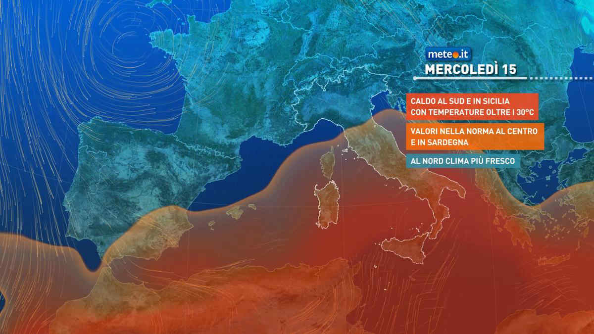
Al mattino annuvolamenti irregolari lungo le Alpi, nelle vicine zone pedemontane e tra Torinese e Cuneese, inizialmente poco nuvoloso nel resto del settore. Temperature minime quasi stazionarie. Nel pomeriggio nuvole in aumento con le schiarite che inizialmente rimangono ampie nel sudest della Lombardia. Il tempo diventa anche piu' instabile con sviluppo di locali rovesci o temporali a ridosso dei rilievi, specie quelli alpini del Piemonte e della Lombardia con successivo coinvolgimento tra tardo pomeriggio e sera anche delle pianure vicine. Temperature massime senza grandi variazioni con punte fino ai 24-25 gradi. Venti deboli salvo rinforzi nelle aree temporalesche. Mar Ligure calmo o poco mosso.

Notizie
TendenzaMeteo: a metà settimana Italia tra intenso maltempo e caldo estivo!
Meteo: a metà settimana Italia tra intenso maltempo e caldo estivo!
Nella parte centrale della settimana saranno possibili temporali di forte intensità al Nord ma anche temperature estive al Sud: la tendenza meteo
Mediaset

Ultimo aggiornamento Domenica 12 Maggio ore 14:01

Copyright © 1999-2020 RTI S.p.A. Direzione Business Digital - P.Iva 03976881007 - Tutti i diritti riservati - Per la pubblicità Mediamond S.p.a. RTI spa, Gruppo Mediaset - Sede legale: 00187 Roma Largo del Nazareno 8 - Cap. Soc. € 500.000.007,00 int. vers. - Registro delle Imprese di Roma, C.F.06921720154