FacebookInstagramTwitterWhatsApp

Meteo Isola delle Femmine tra 3 giorni. Previsioni del tempo, precipitazioni, temperatura e venti

FacebookWhatsappTwitterTelegram

Isola delle Femmine
Vento al pomeriggio
06:13
19:55
Gibbosa calante
Notte
sereno notte
Mattino
soleggiato
Pomeriggio
soleggiato
Sera
sereno notte
  • 18°

    UV Normale 0

    ore

    sereno notte

    Umidità normale60%

    Raffiche forti11-22 Km/h

    Sud est intensoSud E

  • 18°

    UV Normale 0

    ore

    sereno notte

    Umidità normale61%

    Raffiche forti11-21 Km/h

    Sud est intensoSud E

  • 18°

    UV Normale 0

    ore

    sereno notte

    Umidità normale61%

    Raffiche forti10-20 Km/h

    Sud est intensoSud E

  • 18°

    UV Normale 0

    ore

    sereno notte

    Umidità normale62%

    Raffiche forti10-19 Km/h

    Sud est intensoSud E

  • 17°

    UV Normale 0

    ore

    sereno notte

    Umidità normale63%

    Raffiche forti11-20 Km/h

    Sud est intensoSud E

  • 17°

    UV Normale 0

    ore

    sereno notte

    Umidità normale63%

    Raffiche forti12-21 Km/h

    Sud est intensoSud E

  • 17°

    UV Normale 1

    ore

    soleggiato

    Umidità normale64%

    Raffiche forti13-22 Km/h

    Sud est intensoSud E

  • 18°

    UV Normale 2

    ore

    soleggiato

    Umidità normale60%

    Raffiche forti13-22 Km/h

    Sud est intensoSud E

  • 19°

    UV Normale 4

    ore

    soleggiato

    Umidità normale55%

    Raffiche forti14-23 Km/h

    Sud est intensoSud E

  • 20°

    UV Normale 5

    ore

    soleggiato

    Umidità normale51%

    Raffiche forti15-24 Km/h

    Sud est intensoSud E

  • 21°

    UV Elevato 6

    ore

    soleggiato

    Umidità normale51%

    Raffiche forti16-24 Km/h

    Est sud est intensoEst SE

  • 21°

    UV Elevato 7

    ore

    soleggiato

    Umidità normale50%

    Raffiche forti16-24 Km/h

    Est sud est intensoEst SE

  • 22°

    UV Elevato 9

    ore

    soleggiato

    Umidità normale50%

    Raffiche forti16-24 Km/h

    Est sud est intensoEst SE

  • 22°

    UV Elevato 10

    ore

    soleggiato

    Umidità normale49%

    Raffiche forti17-24 Km/h

    Est intensoEst

  • 23°

    UV Elevato 9

    ore

    soleggiato

    Umidità normale49%

    Raffiche forti17-25 Km/h

    Est intensoEst

  • 23°

    UV Elevato 7

    ore

    soleggiato

    Umidità normale48%

    Raffiche forti18-25 Km/h

    Est intensoEst

  • 22°

    UV Elevato 6

    ore

    soleggiato

    Umidità normale49%

    Raffiche forti17-24 Km/h

    Est intensoEst

  • 22°

    UV Normale 4

    ore

    soleggiato

    Umidità normale50%

    Raffiche forti16-24 Km/h

    Est intensoEst

  • 21°

    UV Normale 3

    ore

    soleggiato

    Umidità normale52%

    Raffiche forti15-23 Km/h

    Est sud est intensoEst SE

  • 20°

    UV Normale 1

    ore

    soleggiato

    Umidità normale53%

    Raffiche forti14-22 Km/h

    Est sud est intensoEst SE

  • 20°

    UV Normale 0

    ore

    sereno notte

    Umidità normale54%

    Raffiche forti13-21 Km/h

    Sud est intensoSud E

  • 19°

    UV Normale 0

    ore

    sereno notte

    Umidità normale55%

    Raffiche forti12-21 Km/h

    Sud est intensoSud E

  • 19°

    UV Normale 0

    ore

    sereno notte

    Umidità normale56%

    Raffiche forti11-19 Km/h

    Sud sud est intensoSud SE

  • 18°

    UV Normale 0

    ore

    sereno notte

    Umidità normale57%

    Raffiche normali10-18 Km/h

    Sud sud estSud SE

  • 20°

    UV Normale 0

    ore

    sereno notte

    Umidità normale57%

    Raffiche normali9-17 Km/h

    SudSud

Qualità dell'aria Isola delle Femmine
AccettabileAccettabile
Qualità aria invariataInvariata
ApriDati medi giornata

O3(Ozono)

78.1

NO2(Diossido di azoto)

6.9

SO2(Anidride solforosa)

1.1

PM10(Materia particolata)

14.4

PM25(Materia particolata)

8.0

Meteo Mare Isola delle Femmine

Meteo provincia di Palermo
Meteo Sicilia Italia
Oggi

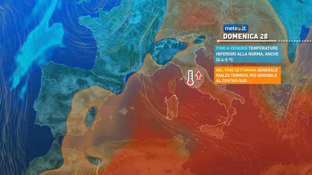
Al mattino nuvole in aumento con qualche pioggia in arrivo nel sudovest della regione. Temperature minime stazionarie o in leggero calo. Nel pomeriggio fase di piogge sparse, localmente anche moderate nel sudest. In serata qualche pioggia ancora solo sul versante tirrenico. Temperature massime in leggero calo; punte fino ai 20-21 gradi nel settore ionico. Venti da moderati a forti occidentali. Mari mossi o molto mossi, localmente anche agitato il Tirreno.

Notizie
TendenzaMeteo, dal 28 aprile picchi oltre 25 gradi: ecco dove
Meteo, dal 28 aprile picchi oltre 25 gradi: ecco dove
Temperature in netto aumento: si torna sopra le medie soprattutto al Centro-sud e sulle Isole dove potremo superare i 25 gradi. La tendenza meteo
Mediaset

Ultimo aggiornamento Giovedì 25 Aprile ore 19:34

Copyright © 1999-2020 RTI S.p.A. Direzione Business Digital - P.Iva 03976881007 - Tutti i diritti riservati - Per la pubblicità Mediamond S.p.a. RTI spa, Gruppo Mediaset - Sede legale: 00187 Roma Largo del Nazareno 8 - Cap. Soc. € 500.000.007,00 int. vers. - Registro delle Imprese di Roma, C.F.06921720154